The Geopolitical Impact of the Mercator Projection
The Mercator Projection, one of the most widely used maps in the world, is not only a cartographic tool, but also carries a strong geopolitical meaning
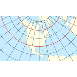
Created in the 16th century by cartographer Gerardus Mercator to aid navigation, this projection preserves angles and directions, but distorts the real size of countries and continents. Regions close to the poles, such as Europe and North America, appear much larger than they actually are, while areas close to the equator, such as Africa and South America, are reduced.
This distortion reinforces historical inequalities, giving the impression that countries in the Northern Hemisphere are more important or dominant. For centuries, this view has influenced international politics, economics and even the cultural perception of nations. Alternatives such as the Gall-Peters Projection attempt to correct these inequalities by representing the continents in their real sizes, but they face resistance due to the consolidated use of the Mercator projection. The debate over maps and geopolitical power continues, showing that the way we see the world can influence the way we think about it.