Azimuthal (Flat or Zenithal) Projection

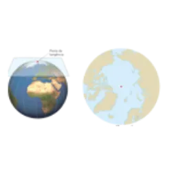
Azimuthal (Flat or Zenithal) Projection: The map is constructed by imagining it situated on a tangent or secant plane to a point on the Earth's surface.
Advantages: Respects the contours and areas of the polar regions;
Disadvantages: Distorts all other regions, especially the equatorial ones.
Also only represents the northern or southern hemisphere.
Note: Uses a plane as a projection surface. In the area where the plane comes into contact with the earth's surface (point of tangency), no deformations occur. As we move away from this point (azimuth), the deformation of the represented surface increases. This type of projection is also called flat projection or polar projection, in the latter case, when the point of tangency is a pole.
Did you know?


