Geographic Information System (GIS)

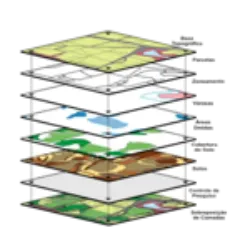
Geographic Information System (GIS): This system digitally represents the territory, overlaying georeferenced information in layers, which makes it possible to create different combinations and interpretations of the reality present in the territory. They are computer systems that enable users to search, visualize, collect, process and transform data related to elements of the Earth's surface, resulting in the construction of maps.
Advantages:
Allows you to work with a large amount of information;#NL # Real-time response to support decision making;
Speed in updating information.
Did you know?


